Orienteering

Orienteering is a running sport involving navigation with a map and compass. The traditional form of orienteering involves cross-country running and navigation. The competition is a timed race in which individual participants use a special purpose map and a magnetic compass to navigate through diverse terrain (often wooded) and visit control points in the correct order. The control points are kept secret from competitors before the start. Competitors start at staggered intervals, are individually timed. Standings are determined first by successful completion of the course, then by shortest time on course.
Map reading and terrain association are supreme in orienteering navigation, and the compass is normally reduced solely to the role of orienting the map to magnetic north.
History
Early days
Orienteering originated in Scandinavia, as a military exercise, in the late 19th century. The competitive sport form began in Norway where the first competition was sponsored by the Tjalve Sports Club on 31 October 1897 and held near Oslo. The course was quite long by modern standards, at 19.5 km, on which only three controls were placed. Peder Fossum won the event in a time of 1 hour, 47 minutes, and 7 seconds.[1] The first large scale orienteering meet was organized in 1918 by Major Ernst Killander of Stockholm, Sweden. Killander was a Scouter who turned to the sport as an opportunity to interest youth in athletics. The first large scale event was organized south of Stockholm and was attended by 220 athletes.[1][2] Killander continued to develop the rules and principles of the sport, and today is widely regarded throughout Scandinavia as the "Father of Orienteering".
The sport gained popularity with the development of more reliable compasses in the 1930s. The first international competition between orienteers of Sweden and Norway was held outside Oslo, Norway in 1932.By 1934, over a quarter million Swedes were actively participating in the sport, and orienteering had spread to Finland, Switzerland, the Soviet Union, and Hungary. The nations of Finland, Norway, and Sweden all established national championships.[3] The Swedish national orienteering society, Svenska Orienteringförbundet, the first national orienteering society, was founded in 1936.[4]
Post war years
Following World War II, orienteering spread throughout Europe, Asia, North America, Australia, and New Zealand.
Eleven countries sent representatives to an international conference in Sandviken, Sweden in 1949 that aimed to bring more consistent rules and mapping standards to the sport. The Norwegians and Swedes began producing new multi-color maps designed specifically for orienteering in the 1950s.
Basics
In competitive orienteering the ability to navigate while running is a key skill.

An orienteering course is marked in purple or red on a map using
- a triangle indicates the start,
- Circles show the control points,
- a double circle indicates the finish.
A staggered start is often used, with competitors starting at one or two-minute intervals. Results are based on the time taken to complete the course, visiting all the controls in the correct order.
High levels of fitness and running speed are required to compete successfully at an elite level. Success also depends on choosing the fastest route between controls. While controls are generally the same for the competitors in any particular category, the routes they choose may be very different. Competitors are often required to cross rough, undeveloped terrain where accurate navigation is essential.
Recently some local orienteering clubs have begun to organize orienteering courses solely for fitness purposes. These may be permanent courses, and are used for practice and training.
Map and control details

Maps are specially created by orienteers and professional cartographers. They are a larger scale and much more detailed than general-purpose topographic maps, and are typically at scales of 1:15,000 or 1:10,000, with grids predrawn to magnetic north. Map symbols for the 1:15000 scale are standardized by the IOF (International specification for orienteering maps - ISOM), and designed to be readable by any competitor no matter his background or native tongue. Map symbols for the 1:10000 scale shall be a 150% enlargement of the symbols for the 1:15000 scale.
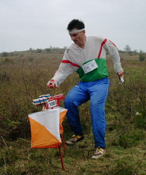
Control points are usually placed on distinct features, and clarified on a "control description sheet". They are marked in the terrain by white and orange (or white and red) flags. A competitor registers his or her visit by punching a "control card" with a needle punch, or using an electronic chip.
Equipment and clothing


The basic equipment required for orienteering is usually listed as a compass, appropriate outdoor clothing and, in some countries, whistle. The whistle is for use in emergency situations. Competitive orienteers usually use specialized equipment, such as a "thumb compass".
GPS and other electronic navigation devices are not normally allowed.
Race types


World Championship distances are Long (winning time of 70 - 80 minutes for women and 90 - 100 mins for men), Middle (30-35 mins), Sprint (10-12 mins) and Relay.
- Relay - Teams of competitors each run a course and the result is based on the team's total time. Relays usually employ a mass start instead of a staggered start. To reduce competitors following each other, parallel courses (called forks) are used where runners on each leg of the race can have different course combinations. Additionally, the legs may be run in different order, so the general area of the event has competitors on totally different courses running perpendicularly to each other. Following a wrong fellow-competitor in such an event will be hazardous. To ensure fairness, the total of all the course combinations is always the same for each team.
- Sprint - Shorter events, often held in city parks and other more urban settings. Map scales are usually 1:5,000 or 1:4,000.
- Night - Competitors use a headlamp to navigate in the dark. Reflective control markers are often used. If a night event starts before dark, then a mass start must be used so all competitors have equal time in the light and dark.
- String - Competitors follow a string around a short course noting down things that they find on the way. This is generally used by young children and people new to the sport who want to find out what it is like.
Recognized types of orienteering
Mountain bike orienteering

This is orienteering on a mountain bike. As bikes are usually not permitted to leave the path system, the major focus becomes route choice while navigating at bike speed. Special equipment required is a map holder attached to the handlebar of the bike. Maps are usually smaller scale and less detailed than standard orienteering maps.
Ski orienteering
Another variant includes orienteering on cross-country skiing. Standard orienteering maps are used, but with special green overprinting of trails and tracks to indicate their navigability in snow; other symbols indicate whether any roads are snow-covered or clear. Standard cross-country ski equipment is used, along with a map holder attached to the chest.
Trail orienteering
An orienteering form accessible to disabled competitors where the object is accuracy, not time. It involves determining, along a set accessible course, which of various controls in a small area is the one indicated on the map. Another less common form involves determining the position on a map of a control viewed from a set point 30-40 metres away. Maps are usually 1:5,000 scale.
Other variations of orienteering
There are many other orienteering variations where a means of locomotion is combined with a navigational element:
- Motor vehicle - a motorsport where roads have to be driven in a specific time.
- Mounted - Mounted Orienteering is performed on horseback.
- Canoe - This is best done in an area with many small islands and a complex shoreline. Frequently, two-person teams compete using one canoe. Some controls are accessible by water and others by land. An important part of the strategy is choosing both water and land routes so that the controls are encountered efficiently, and neither team member wastes time waiting for the other.
- Radio - Competitors find unmarked controls at which radio transmitters are located. Each runner is given a standard orienteering map with start and finish locations marked, and uses a compass and hand-held radio receiver to locate each transmitter site, at which a standard orienteering control and punch is located. Scoring is by number of transmitters found, then shortest time on course.
See also
References
- ↑ 1.0 1.1 Palmer, Peter (1997). The Complete Orienteering Manual. Wiltshire, England: The Crowood Press Ltd., ISBN 1-86126-095-4, p. 18-19.
- ↑ Boga, Steven (1997). Orienteering: The Sport of Navigating with Map & Compass. Mechanicsburg, Pennsylvania, USA: Stackpole Books. ISBN 0-8117-2870-6. p. 1.
- ↑ Palmer, Peter (1997). The Complete Orienteering Manual. Wiltshire, England: The Crowood Press Ltd., ISBN 1-86126-095-4, p. 20.
- ↑ Boga, Steven (1997). Orienteering: The Sport of Navigating with Map & Compass. Mechanicsburg, Pennsylvania, USA: Stackpole Books. ISBN 0-8117-2870-6. p. 2.